Management Team
Gold, Silver and Base Metals – Historic Mines
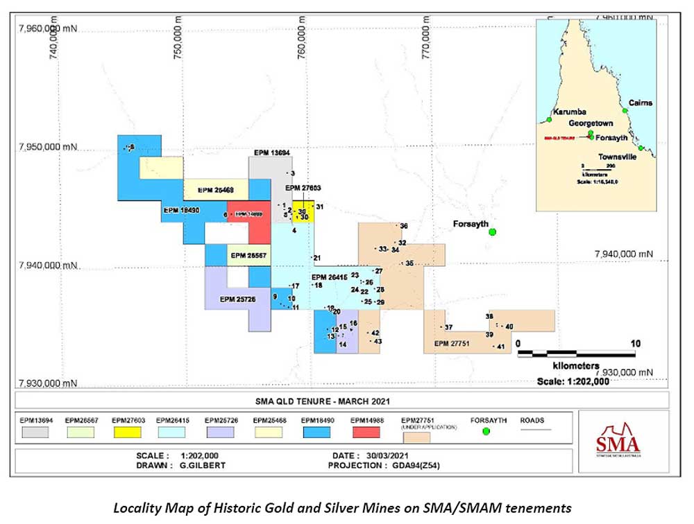
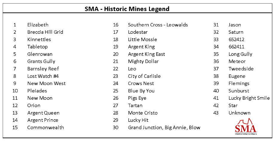
SMA – Historic Mines Legend
Historic Mining in the Upper Mosquito Creek Silver-Lead-Zinc Province
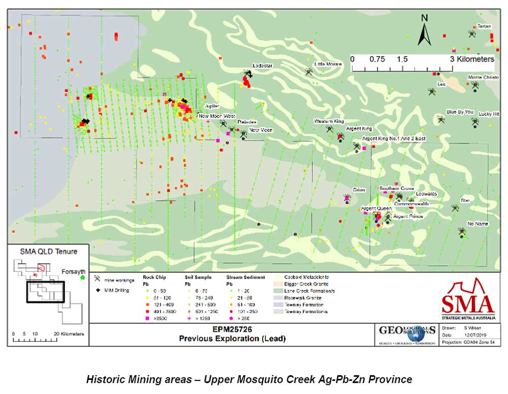
Numerous old mines lie within a province known as Upper Mosquito Creek silver province. The map above shows the broad distribution of old mines in this province. For Silver-Lead-Zinc these mines may be grouped into three main clusters from west to east: New Moon group, Argent King group and Southern Cross group. The Southern Cross group mines have been mapped and sampled in detail and are now “drill ready for resource definition”.
Silver production appears to have commenced in 1906 at the Orion mine and extended until approximately 1930 with a second period of mining around 1947 – 52. The target mineral was galena (lead) in high grade veins. Silver values were presented in terms of ounces/ton of lead. Old records indicate that the converted grades for silver ranged from 6.8Kg/tonne lead produced for the New Moon group, 0.83Kg/t for the Argent King group, 2.5 – 3.95 Kg/t for the Orion – Southern Cross group. One estimate (CR 17255) suggests over 19 tonnes of silver has been recovered from small mines in this Province.
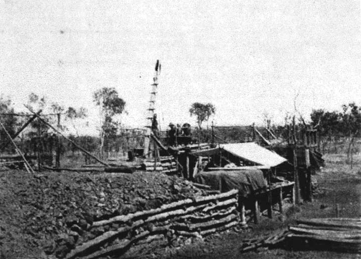
Recorded production from Leowalds shaft includes ¬16,500oz silver and 317 tonnes lead during the period 1912 – 1919; sporadic re-processing of surface 2nd and 3rd grade waste stockpiles produced a further 2,200Oz silver and 37tonnes lead during the period 1920 – 1949.
In the period prior to World War I ore was handpicked and carted a long distance to Chillagoe for treatment. This smelter closed at the start of the war so many mines in the Georgetown area were then closed. Little attention was paid to the extent of mineralization; either at depth or laterally to known veins. Detailed field mapping and core drilling is almost non-existent in the region. The deepest shaft appears to be 56 metres (Leowalds) with most mines terminated at the water table around 25 metres depth. Subsequent exploration has been cursory in nature.
Southern Cross mine (EPM 25726 – 100% SMA)
The table below shows assays of gossan samples taken earlier from the Southern Cross silver-lead-zinc mine dumps. As expected from historical production these gossans record a mineral lode that is rich in silver, lead and zinc. Assays show enrichment in tantalum also. This was unexpected. Minor gold is also reported in several samples. It is noted for both tables that samples are “seconds” taken from dumps. All high-grade ore was hand sorted and despatched by the miners for processing so these assays are indicative only.
The very unusual association of silver and tantalum is found in the Southern Cross and Orion mines. Petrological studies have revealed three periods of mineralisation have occurred. First was sphalerite (zinc) mineralisation, followed and partially replaced by galena (lead), silver and tantalum. The final phase of mineralisation saw gold-bearing pyrite with minor copper introduced. It is important to note that the zinc and lead credits are significant for this mine.
| Sample # | Nb2O5 (ppm) | Ta2O5 (ppm) | Ag (ppm) | Au (ppm) | CuO (ppm) | ZnO (%) | As2O3 (ppm) | PbO (%) |
| 1285 | 320 | 790 | 913 | 0.482 | 5450 | 9.6240 | 0 | 27.9510 |
| 810 | 160 | 710 | 36 | 0.090 | 330 | 16.5290 | 470 | 0.8860 |
| 1664 | 620 | 520 | 622 | 0.121 | 2450 | 46.3160 | <10 | 28.7500 |
| 1385 | 180 | 480 | 168 | 0.15 | 540 | 10.2010 | 0 | 11.3060 |
| 100 | 240 | 320 | 307 | 0.205 | 920 | 6.8200 | 4020 | 11.1250 |
| 1667 | 640 | 270 | 442 | 0.57 | 1930 | 13.8470 | 1310 | 25.2220 |
| 1384 | 0 | 230 | 10 | 0.02 | 290 | 10.4970 | 120 | 0.4060 |
| 1666 | 470 | 170 | 619 | 2.731 | 930 | 5.4080 | 40210 | 23.6770 |
| Average | 329 | 436 | 390
= 12.6 oz/tonne |
0.546 | 1605 | 14.905 | 5766 | 16.164 |
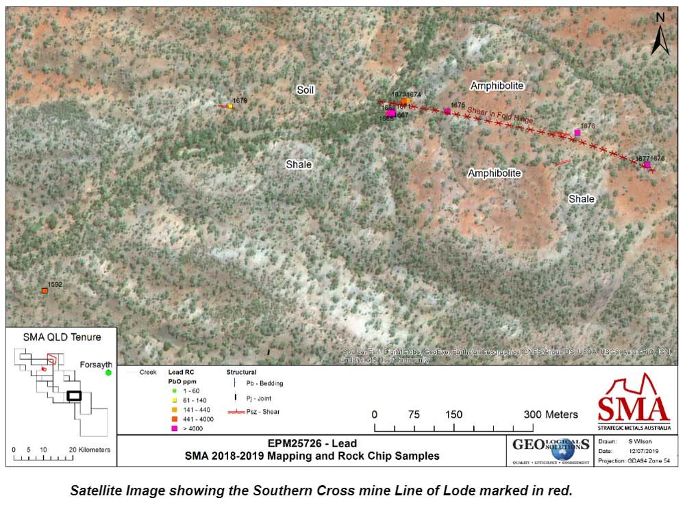
SMA has identified the Southern Cross – Leowalds line of lode as a priority target for evaluation. The line of lode is shown on the satellite image below. Note the main road passes close by in the southeast corner of the figure. A powerline follows this road.
Micro-XRF Geochemistry and Mineralogy Report
Portable Spectral Services Pty Ltd in Perth analysed 3 gossan samples from the Southern Cross dump. The principal mineralogy identified consisted of galena (lead), quartz, sphalerite (zinc), manganese oxide and zinc oxide. Minor minerals included chalcopyrite (copper), pyrite (usually carries gold) and ankerite (a carbonate associated with mineralising systems).
An important finding from this study was that silver occurs as a separate mineral phase hosted within the quartz rather than the galena. As the early miners focussed on extracting the highly visible galena lead ore the implication is that silver mineralisation may be more extensive and of higher grade than in the ore mined.
Orion Mine (EPM 18490 – 95% SMA Mining)
SMA also sampled gossans from the Orion mine that lies ~ 1.5 km due west of the Southern Cross – Leowalds line of load and appears to be on the same regional structure. This structure extends an estimated 10 kms further to the east of Leowalds. SMA now has this ground under application (EPM 27551).
The results below are from gossans taken on the old dumps around the Orion mine shaft. The Orion mine was reported as averaging ~ 46 ozs Ag/tonne in lead ore. Again, it is important to note that the zinc and lead credits are significant for this mine.
Table 2.4: Orion Mine Gossan Assays.
|
Sample # |
Nb2O5 (ppm) |
Ta2O5 (ppm) |
Ag (ppm) |
Au (ppm) |
CuO (ppm) |
ZnO (%) |
As2O3 (ppm) |
PbO (%) |
|
RC1795 |
<10 |
90 |
8 |
0.031 |
300 |
11.275 |
70 |
0.255 |
|
RC1796 |
160 |
120 |
137 |
0.048 |
410 |
12.129 |
2050 |
10.488 |
|
RC1797 |
30 |
230 |
20 |
0.056 |
700 |
21.477 |
780 |
1.245 |
|
RC1798 |
<10 |
120 |
176 |
0.050 |
3700 |
9.489 |
470 |
1.240 |
|
RC1799 |
30 |
80 |
452 |
0.156 |
2690 |
5.178 |
1090 |
2.057 |
|
Average |
44 |
128 |
159 |
0.068 |
1560 |
11.91 |
892 |
3.057 |
Silver Resource Evaluation
Southern Cross Lode (EPM 25726)
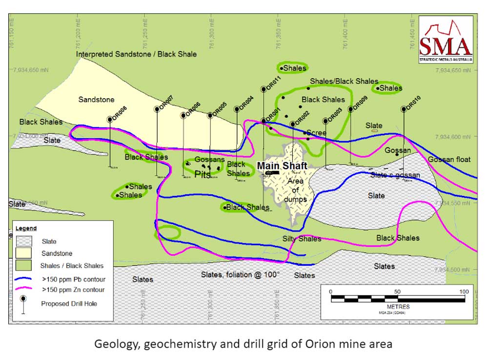
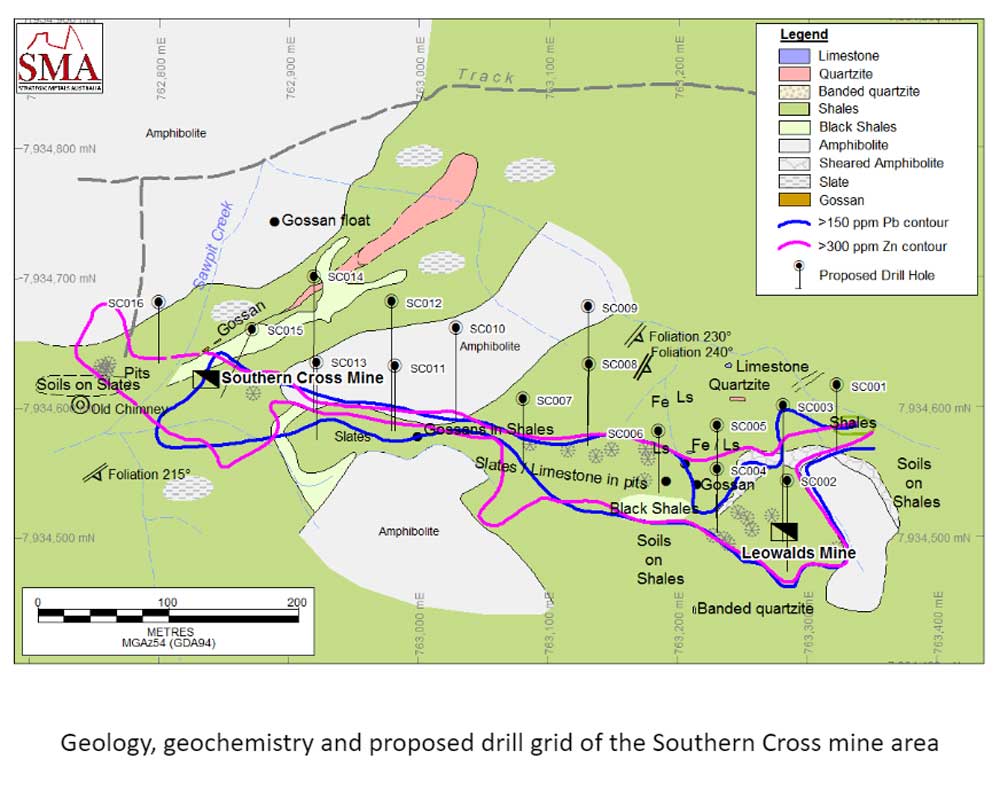
SMA has completed detailed mapping and geochemical sub soil sampling on the Southern Cross/Leowalds and Orion mines found on EPM’s 18490 and 25726. These mines are formed along linear structures in metasediment host rocks formed by shearing against harder amphibolites. The map below shows the geology of the immediate mine area, geochemical contours for both lead and zinc that outline the surface area of the mineralisation, and the planned drill grid. All sites have been ground proofed.
Orion Lode (EPM 18490)
Surface mapping of the Orion mine area followed the main line of lode further to both the east and west than indicated by surface pitting. The geochemical contouring from 120 sub soil samples showed the zinc anomaly to be widespread and to cover a broader area than previously thought. The area of anomaly for lead is more confined but does highlight the presence of a potential second line of lode along the contact with a unit of slates to the south of the main shaft. Drilling is planned to evaluate the east-west extension of the main lode.
